New crime mapping website helps keep residents in the picture
|
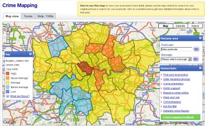
The crime rate in the W12 area is “average”, compared to the rest of London, according to a new crime mapping website which allows Londoners to find out about crime levels in their neighbourhood.
According to the site, which divides areas into "'high", "above average", "average", "below average" and "low", the W12 Wards all fall into the “average” bracket when rates of burglary, robbery and vehicle crime are measured across the capital.
The crime mapping website, which was launched by the Mayor of London, provides a set of interactive maps, showing numbers and rates of crime, and links to the Safer Neighbourhoods Team web pages. Visitors can ‘zoom in’ and ‘zoom out’ to examine crime levels in their chosen areas at Borough, Ward and Sub-Ward levels. The site also compares the crime levels in local neighbourhoods to the London average.
The figures for W12 show that in both Wormholt and White City and Askew Wards, the number of recorded crimes dropped between June and July this year, while in College Park and Old Oak Ward, the figures stayed the same.
In the Shepherd’s Bush Green area, however, the number of reported burglaries, robberies and vehicle crimes increased from 18 in June to 26 in July.
The crime rate is "average" across Hammersmith and Fulham as a whole, with 409 crimes recorded in July 2008, compared to 16376 across London in the same period. The borough has seen a year-on-year drop in its crime rate from 7577 in 2005/6 down to 6260 in 2007/8, according to the site.
Mayor Boris Johnson said: “This new online service means that Londoners will, at long last, be able to get information about crime levels in their neighbourhood at the click of a button. Crime mapping puts information into the hands of every London citizen about the levels of crimes, as well as contact details of their local police officers. This is a major step forward in enabling Londoners to really be able to assess the work of their local police in tackling the crimes that affect their neighbourhood.”
Deputy Commissioner of the Metropolitan Police, Sir Paul Stephenson said: “There has been a growing and understandable appetite for people to know more about what crime is happening in their local areas. We've deliberately made these new crime maps as easily accessible and user -friendly as possible with the aim of increasing communication and trust between the public and the police.
“We have found that in some cases, Londoners’ perception of crime is higher than the reality and the crime maps may help to reassure communities about the general safety of their local area."
4 September 2008